Google portrayed an innovative navigation system that leveraged the phone’s camera to provide augmented reality GPS guidance, in May. However, the feature wasn’t expected to be immediately available, even for testing. The company is now letting select people preview the version of Maps. David Pierce from the Wall Street Journal was one of the lucky ones to give it the first try.
Rachel Inman of Google, who works on the user experience for the new feature, said that the company hopes to simplify the transition between the two-dimensional map on the phone and the three-dimensional world around you. The primary goal is to make navigation more straightforward, he added.
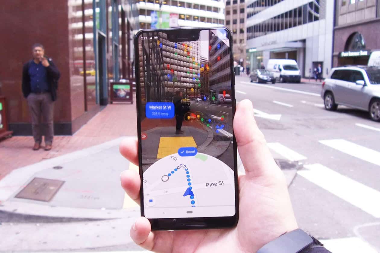
Google uses artificial intelligence to help understand where things are. The company has a decade of street images and landmarks around the world from its Street View program.
The future version of the Map’s application lets you access a particular AR mode through a dedicated button or by lifting your phone. Initially, you’ll be prompted to move your handset around so it can recognize surrounding landmarks to compare them. The camera’s input will then be visible on your screen, and the app will overlay arrows pointing towards your destination, making it simple than usual. You’ll still be able to see the traditional map that will give you a bird’s eye view of where you’re currently headed. The company isn’t expecting you to use this feature throughout the entire guidance but instead wants you to navigate complex intersections with ease. Even if you keep walking with your camera pointed at the street, the app will eventually ask you to put the device down to save your phone’s battery as you’re only supposed to use it sparsely.
Google said the feature is now being offered only for a small group of people who often use and contribute to Google Maps. The company does not say when it will generally be available.
Technically, a smartphone uses its built-in GPS and compass to determine your location the direction you are facing in a mapping app. However, considering the crowded cities, this can get a little tricky. The GPS relies on having a line of sight to pass along radio signals from remote satellites to directly your phone, making it difficult for tall buildings to figure out where exactly you are.
Once the app has a specific idea of where you are, then it can overlay virtual images on what it sees with your phone’s camera. Most likely they look like they are integrated with reality. This feature has long been a challenge for many companies building Augmented Reality into smartphone apps.
For now, Google is trying to keep these images simple. The previous prototype of the AR feature displayed fireworks when a user approached the destination in Google Maps, said Gorecki. The team decided that it wasn’t a good idea.
“It was mostly a distraction,” he said. “You don’t want to overdo it.”